Difference between revisions of "Nebraska Historical Marker: School District 35, The Killough School"
(→Marker Text) |
(→Location) |
||
| Line 2: | Line 2: | ||
==Location== | ==Location== | ||
| − | + | County Rd 2400, .5 mile south of intersection of Co Rd 2400 and Co Rd Q, Guide Rock, Webster County, Nebraska | |
View this marker's location '''[https://maps.google.com/maps?q=40.198380,+-98.29301&hl=en&ll=40.198609,-98.293047&spn=0.027305,0.038581&sll=40.087656,-98.51987&sspn=0.006837,0.009645&t=h&z=15 40.198380, -98.29301]''' | View this marker's location '''[https://maps.google.com/maps?q=40.198380,+-98.29301&hl=en&ll=40.198609,-98.293047&spn=0.027305,0.038581&sll=40.087656,-98.51987&sspn=0.006837,0.009645&t=h&z=15 40.198380, -98.29301]''' | ||
Latest revision as of 07:39, 20 September 2017
Location
County Rd 2400, .5 mile south of intersection of Co Rd 2400 and Co Rd Q, Guide Rock, Webster County, Nebraska
View this marker's location 40.198380, -98.29301
View a map of all Nebraska historical markers, Browse Historical Marker Map
Marker Text
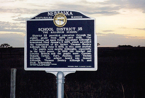
District 35 provided education through the eighth grade from 1879 until 1958. The schoolhouse sat upon Felix Alexander Killough's homestead, filed January 2, 1879, which adjoined the homestead of his father, Thomas Donley Killough, filed June 9, 1875, in this same section.
The pupils were mostly Killoughs, especially in the later years. In 1928 the teacher was Loretta Britten and the pupils were Corrine, Donald, Esther, Fern, Pauline, and Thelma Killough. The school board was Samuel Killough, Thomas Donley Killough II, and Fred Schroeder.
Further Information
Bibliography
Marker program
See Nebraska Historical Marker Program for more information.
