Difference between revisions of "Nebraska Historical Marker: Nebraska City"
| (2 intermediate revisions by the same user not shown) | |||
| Line 1: | Line 1: | ||
| − | [[Image:NHM_60_1_1.jpg|thumb|center|upright= | + | [[Image:NHM_60_1_1.jpg|thumb|center|upright=2.0|alt=NHM_60_1_1.jpg]] |
==Location== | ==Location== | ||
| Line 6: | Line 6: | ||
View this marker's location '''[https://maps.google.com/maps?q=40.673479,+-95.87219&hl=en&ll=40.673584,-95.872171&spn=0.006957,0.013937&sll=40.680459,-95.881784&sspn=0.006957,0.013937&t=h&z=17 40.673479, -95.87219]''' | View this marker's location '''[https://maps.google.com/maps?q=40.673479,+-95.87219&hl=en&ll=40.673584,-95.872171&spn=0.006957,0.013937&sll=40.680459,-95.881784&sspn=0.006957,0.013937&t=h&z=17 40.673479, -95.87219]''' | ||
| − | + | {{Marker:Map}} | |
==Marker Text== | ==Marker Text== | ||
| Line 17: | Line 17: | ||
''With the building of the Union Pacific Railroad, overland freighting from Nebraska City soon gave way to railroad shipment. | ''With the building of the Union Pacific Railroad, overland freighting from Nebraska City soon gave way to railroad shipment. | ||
==Further Information== | ==Further Information== | ||
| − | + | [[Image:Main_Street_Looking_West_Nebraska_City_Print.jpg|thumb|center|upright=3.0|alt=Main_Street_Looking_West_Nebraska_City_Print.jpg]] | |
| + | [[Image:Missouri_River_Nebraska_City_Print.jpg|thumb|center|upright=3.0|alt=Missouri_River_Nebraska_City_Print.jpg]] | ||
| + | [[Image:Karl_Giles_and_Howard_Crouch.jpg|thumb|center|upright=3.0|alt=Karl_Giles_and_Howard_Crouch.jpg]] | ||
==Bibliography== | ==Bibliography== | ||
| + | William E Lass, “Nebraska City’s Steam Wagon,” Nebraska History 79 (1998): 24-33 | ||
| − | + | Elton A. Perkey, “Perkey’s Nebraska Place Names” (1995), Nebraska State Historical Society | |
| − | + | {{Marker:Program}} | |
Latest revision as of 11:41, 19 January 2018
Location
2120-2182 State Highway 2 Bus, Nebraska City, Otoe County, Nebraska
View this marker's location 40.673479, -95.87219
View a map of all Nebraska historical markers, Browse Historical Marker Map
Marker Text
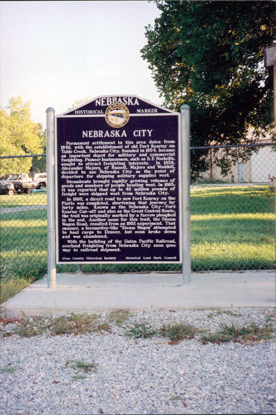
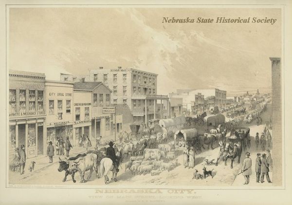
Permanent settlement in this area dates from 1846, with the establishment of old Fort Kearny on Table Creek. Nebraska City, founded in 1854, became an important depot for military and commercial freighting. Pioneer businessmen, such as S. F. Nuckolls, sought to attract freighting interests. In 1858, Alexander Majors, of Russell, Majors and Waddell, decided to use Nebraska City as the point of departure for shipping military supplies west.
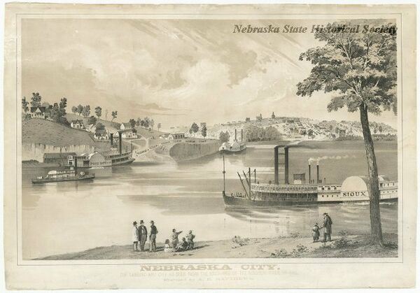
Steamboats brought rapidly growing volumes of goods and numbers of people heading west. In 1865, it was reported that up to 40 million pounds of freight were shipped west from Nebraska City.
In 1860, a direct road to new Fort Kearny on the Platte was completed, shortening that journey by forty miles. Known as the Nebraska City-Fort Kearny Cut-off and also as the Great Central Route, the trail was originally marked by a furrow ploughed in the sod. Another name for this trail, the Steam Wagon Road, resulted from an 1862 experiment. That summer, a locomotive-like "Steam Wagon" attempted to haul cargo to Denver, but soon broke down and was abandoned.
With the building of the Union Pacific Railroad, overland freighting from Nebraska City soon gave way to railroad shipment.
Further Information
Bibliography
William E Lass, “Nebraska City’s Steam Wagon,” Nebraska History 79 (1998): 24-33
Elton A. Perkey, “Perkey’s Nebraska Place Names” (1995), Nebraska State Historical Society
Marker program
See Nebraska Historical Marker Program for more information.


