Difference between revisions of "Nebraska Historical Marker: Giant Glacial Boulder"
(Created page with "[[Image:________ |thumb|center|upright=3.0|alt=________]] ==Location== 1340 Manatt St, Lincoln, Lancaster County, Nebraska View this marker's location '''[https://maps.googl...") |
m |
||
| Line 1: | Line 1: | ||
| − | [[Image: | + | [[Image:NHM_266_1_1.jpg|thumb|center|upright=3.0|alt=NHM_266_1_1.jpg]] |
==Location== | ==Location== | ||
Revision as of 14:34, 3 December 2014
Location
1340 Manatt St, Lincoln, Lancaster County, Nebraska
View this marker's location 40.848384, -96.70135
View a map of all Nebraska historical markers, Browse Historical Marker Map
Marker Text
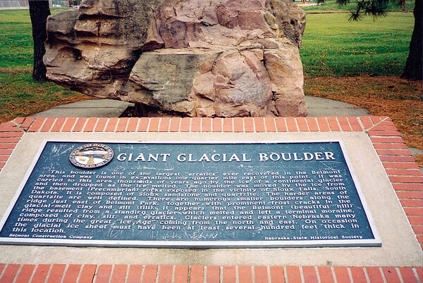
This boulder is one of the largest "erratics" ever recovered in the Belmont area, and was found in excavations one-quarter mile east of this point. It was carried to this area thousands of years ago by the ice of a continental glacier and then dropped as the ice melted. The boulder was moved by the ice from the basement (Precambrian) rocks exposed in the vicinity of Sioux Falls, South Dakota. It is composed of Sioux sandstone and quartzite. The harder areas of quartzite are well defined. There are numerous smaller boulders along the ridge just east of Belmont Park, together with prominent frost cracks in the glacial-melt clay and silt (till). It appears that the Belmont (beautiful hill) ridge resulted from a standing glacier which melted and left a terminal moraine, composed of clay, silt, and erratics. Glaciers entered eastern Nebraska many times during the great "Ice Age" coming from the north and east. On occasion the glacial ice sheet must have been at least several hundred feet thick in this location.
Further Information
Bibliography
Marker program
See the Nebraska Historical Marker Program for more information.
