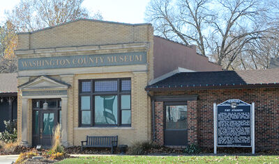
Nebraska Historical Marker: Fort Atkinson (2)
Location
102 N 14th St, Fort Calhoun Post Office, Washington County, Nebraska
View this marker's location 41.456228, -96.02676
View a map of all Nebraska historical markers, Browse Historical Marker Map
Marker Text
Civilization came to the west bank of the Missouri with establishment of Fort Atkinson in 1820 about a half mile southeast of here. Named after its founder, General Henry Atkinson, this western-most Fort protected the frontier's developing commerce. Established as a temporary camp in 1819, Fort Atkinson was the largest and strongest outpost above St. Louis. The permanent post went up a year later on the site of Lewis and Clark's Council with the Oto and Missouri Indians. From Fort Atkinson troops under the command of Col. Henry Leavenworth moved up the Missouri River in 1823 to punish the Arikara Indians after an attack on William H. Ashley's fur trading party. Members of the garrison ascended the river in 1825 on a mission of peace, participating in a series of treaties with the Indians. This spearhead of white civilization was abandoned in 1827. But in seven years Fort Atkinson had brought the first school, the first white family life, a library, a sawmill, a brickyard, a grist mill, and large-scale agriculture of the west bank of the Missouri.
Further Information
Bibliography
Sally A Johnson, “Fort Atkinson at Council Bluffs,” Nebraska History 38 (1957): 229-236
Virgil Ney, “Prairie Generals and Colonels at Cantonment Missouri and Fort Atkinson,” Nebraska History 56 (1975): 51-76
Marker program
See Nebraska Historical Marker Program for more information.
