Difference between revisions of "Nebraska Historical Marker: B-17 Crash, 1943"
| Line 6: | Line 6: | ||
View this marker's location '''[https://maps.google.com/maps?q=40.887665,+-98.62455&hl=en&ll=40.887774,-98.624557&spn=0.006756,0.009645&sll=40.922495,-98.345575&sspn=0.006753,0.009645&t=h&z=17 40.887665, -98.62455]''' | View this marker's location '''[https://maps.google.com/maps?q=40.887665,+-98.62455&hl=en&ll=40.887774,-98.624557&spn=0.006756,0.009645&sll=40.922495,-98.345575&sspn=0.006753,0.009645&t=h&z=17 40.887665, -98.62455]''' | ||
| − | + | {{Marker:Map}} | |
==Marker Text== | ==Marker Text== | ||
| Line 15: | Line 15: | ||
==Bibliography== | ==Bibliography== | ||
| − | + | {{Marker:Program}} | |
| − | + | ||
Revision as of 14:44, 11 September 2017
Location
14743-14937 W Husker Hwy, Wood River, Hall County, Nebraska
View this marker's location 40.887665, -98.62455
View a map of all Nebraska historical markers, Browse Historical Marker Map
Marker Text
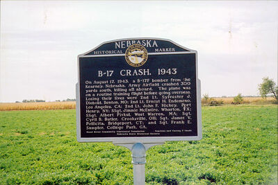
On August 17, 1943, a B-17F bomber from Kearney, Nebraska, Army Air Field crashed 300 yards south, killing all aboard. The plane was on a routine training flight before going overseas. Losing their lives were 2nd Lt. Sylvester J. Diebold, Benton, MO; 2nd Lt. Ernest H. Endemano, Los Angeles, CA; 2nd Lt. John F. Hickey, Port Henry, NY; SSgt Jimmie McEntire, Wharton, TX; SSgt Albert Pivkul, West Warren, MA; Sgt. Cyril B. Butler, Crooksville, OH; Sgt. James V. Pollicita, Bridgeport, CT; and Sgt. Frank E. Sampler, College Park, GA.
Further Information
Bibliography
Marker program
See Nebraska Historical Marker Program for more information.
