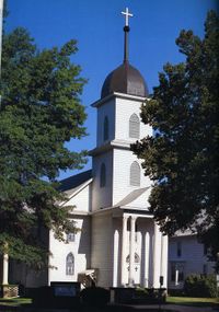
NRHP: South Bottoms Historic District
Contents
South Bottoms Historic District
NRHP Reference #: 86001717
NRHP Listing Date: 19860717
Location
bounded by M, J, H, G, 2nd & 9th, W B & Salt Cr, Lincoln, Lancaster County, Nebraska
View this property's location
View all NRHP properties on this map.
Summary
The South Bottoms Historic District, a predominantly residential area, with a park, school, churches, commercial buildings, and agricultural outbuildings, is located on the flood plain of Salt Creek along Lincoln's western edge. Built and occupied almost exclusively by Germans from Russia who emigrated to this area from the Volga River region, the district occupies approximately seventy-four square blocks and comprises over 1,000 properties. The largest and probably the most distinct urban ethnic neighborhood in the state, the South Bottoms exemplifies the importance of immigrants in settling the cities and towns of the Great Plains. With the predominant Volga-German culture of the neighborhood, the district portrays the architectural character of an Old World village.
Further Information
Bibliography
About the National Register of Historic Places
The National Register of Historic Places (NRHP) is the country’s official list of historically significant properties. To be eligible for the NRHP a property must generally retain their historic appearance, be at least 50 years old, and have the potential to be documented as historically or architecturally significant at either the local, state, or national level. The National Register of Historic Places is a National Park Service program administered by the Nebraska State Historical Society for the state of Nebraska. Visit the Nebraska State Historical Society's website to learn more about the program.
