Difference between revisions of "Nebraska Historical Marker: Springfield Community Hall"
(Created page with "[[Image:________ |thumb|center|upright=3.0|alt=________]] ==Location== 100-104 N 1st St, Springfield, Sarpy County, Nebraska View this marker's location '''[https://maps.goo...") |
|||
| (One intermediate revision by one other user not shown) | |||
| Line 1: | Line 1: | ||
| − | [[Image: | + | [[Image:NHM_410_1_1.jpg|thumb|center|upright=3.0|alt=NHM_410_1_1.jpg]] |
==Location== | ==Location== | ||
| Line 6: | Line 6: | ||
View this marker's location '''[https://maps.google.com/maps?q=41.082016,+-96.13476&hl=en&sll=41.13951,-95.894133&sspn=0.006731,0.009645&t=h&z=17 41.082016, -96.13476]''' | View this marker's location '''[https://maps.google.com/maps?q=41.082016,+-96.13476&hl=en&sll=41.13951,-95.894133&sspn=0.006731,0.009645&t=h&z=17 41.082016, -96.13476]''' | ||
| − | + | {{Marker:Map}} | |
==Marker Text== | ==Marker Text== | ||
| Line 21: | Line 21: | ||
==Bibliography== | ==Bibliography== | ||
| − | + | {{Marker:Program}} | |
| − | + | ||
Latest revision as of 13:01, 12 September 2017
Location
100-104 N 1st St, Springfield, Sarpy County, Nebraska
View this marker's location 41.082016, -96.13476
View a map of all Nebraska historical markers, Browse Historical Marker Map
Marker Text
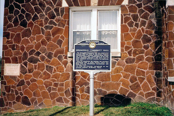
The Springfield Community Hall was constructed between 1938 and 1940 by the Works Progress Administration, a national relief program during the Great Depression. Construction of the hall, using sandstone quarried a few miles west of town, bolstered the local economy by employing area men. Since its completion, the building has provided Springfield with a public facility which has been used for educational, recreational, and political events. In 1998 the structure was placed on the National Register of Historic Places.
Further Information
Bibliography
Marker program
See Nebraska Historical Marker Program for more information.
